35th Annual NHAA Omer T. Lassonde Juried Exhibition, “Beyond the Boundaries”
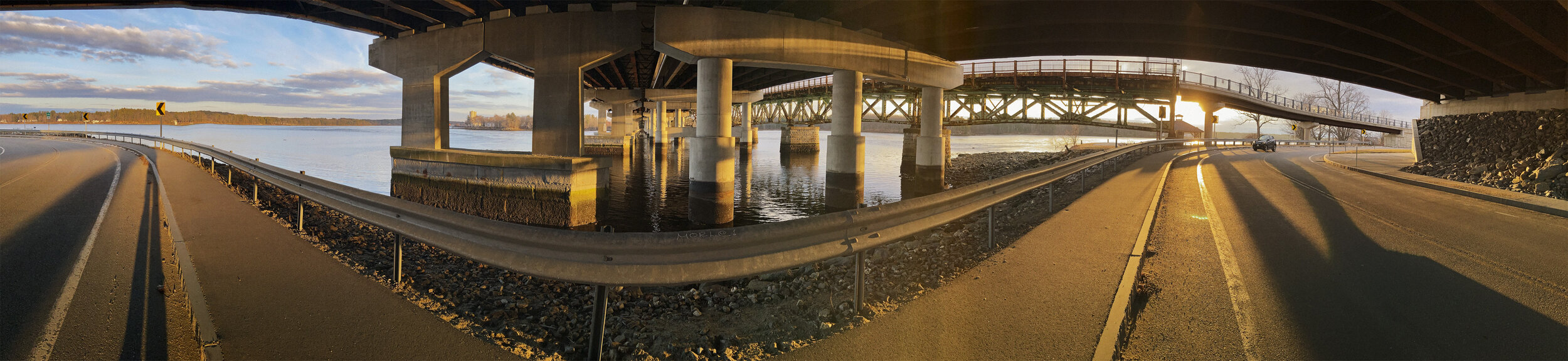
“View From Hilton Point Park #2”
One of my photographs, “View from Hilton Park #2” was selected for the 35th Annual NHAA Omer T. Lassonde Juried Exhibition, “Beyond the Boundaries”, will be on view at the Robert Levy Gallery in Portsmouth, NH from March 31 to May 30, 2021. The opening reception takes place on Zoom Thursday, April 15th at 6:30 PM.
The juror for this exhibit will be Andrew Spahr, Chief Curator at the Currier Museum of Art in Manchester, NH.
Hilton Point sits at the end of a small peninsula in the Piscataqua River. The current is tidal and swift and can reach 6 Knots as the river flows from this point seven miles down stream to Portsmouth Harbor and on to the open Atlantic.
In this view, to the far left the Piscataqua drains the Cocheco and Salmon Falls River. It marks the southern border of the State of Maine. From Kittery, at its mouth, the Maine coastline extends 230 miles to Passamaquoddy Bay and the St. Croix River which marks the border with Canada. At the middle third of the picture, across the channel is Bloody Point with the metal tower of the Sprague Terminal just beyond. Under the bridge and to the right the Piscataqua flows into Great Bay, the sixth largest estuary in the United States. Seven rivers drain into Great Bay connecting non-contiguous towns on land creating what is known as “Seacoast New Hampshire”.
The pylons and the undersides of three bridges reflect how commerce and traffic developed through the years. To the far right is a narrow two-lane bridge which now serves pedestrian and bike traffic. To the far left is a four-lane span that replaced it and carries highway traffic for Rt.16 northward to the White Mountains. The newest link in the center, completed in 2021 as part of a ten-year construction project, doubled the capacity of vehicular traffic to a total of eight lanes. Just upstream,beyond the far right of the picture, a much older structure, the Picataqua Bridge, carried traffic for sixty years until it was replaced in 1885.
Aboriginal tribes occupied this land long before the arrival of the Europeans. The name Piscataqua may have been derived from the Abenaki pesce-tegwe – branch of the fast-flowing river or the place where a river separates into two or three parts. In the early 17th century as many as 20,000 persons might have occupied the area in what is now the State of Maine. Hilton Point is the European place name given to the area by two brothers, William and Edward Hilton, in the 1620’s. They relocated to the area from Odiorne Point, their original settlement, a strategic location on the coast at the mouth of the Piscataqua. and the closest on shore site to the Isle of Shoals, an early European fishing outport.
The image is an I-Phone panorama. You can see more of my panoramic images in the panorama gallery.